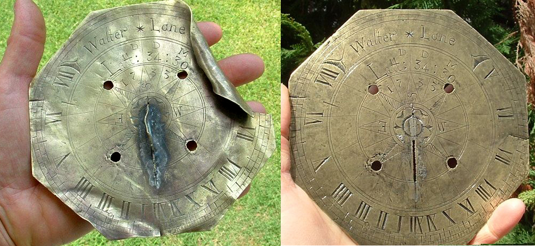
 It started simply enough. Keith, a "treasure hunter" reported finding a 1733 sundial "in the Carolinas". (http://www.treasurenet.com/forums/my-best-finds/603181-1733-colonial-sundial-found-restored.html). The brass sundial about 5 or 6 inches in size was found crumpled and apparently had a number of modern attempts to solder a gnomon back onto the dial plate. Kieth reported, "When I found the piece it had been bent and damaged so I sent it to an expert in restoring metal objects....It has been the best find of my relic hunting career. I hope to get some detailed info from people who know about sundials."
The dial is done in the English style of the period, that is to say, the dial is cut as an octogon with a circular chapter ring with Roman numerals and delineated on the outside to the quarter hour. In the center is an 8-point compass rose with the cardinal points labelled "N,S,E,W". Four crude and somewhat modern screw holes held the dial to some modern base. The maker's initials D.D.M. are berlow the engraving of the original owner "Walter * Lane" with the date 1733.
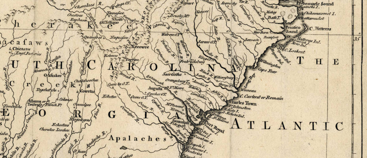
As Kieth notes, "[The dial] is one of the earliest from southern colonial America". But the problem is where? The engraved latitude is "Latt: 34:30". Using Serle's ruler confirms that the delineated hour lines are between 34 and 35 degrees. That should allow a quick check of southern cities to identify the home of this dial. The center of population in the 1750's was Willmington, NC at 34:14. If we assume that William Lane was a farmer a person of means, then two possibilities arise: Blenheim SC and Laurens SC both at 34:30. Laurens County, in particular, was in the area where thousands of immigrants, mainly Scottish and Irish, settled in the pre-revolution Carolinas. Then there is Kershaw SC at 34:32 which was settled around 1732 by English traders and farmers who moved inland from Charleston. What was the provinance of this dial? We may never know, but you can search the below 1755 map from University of North Carolina library of historic maps for towns and river portsat: https://dc.lib.unc.edu/cdm/ref/collection/ncmaps/id/123
NEW INFORMATION:
A descendent of Walter Lane sent the following: Walter Lane lived in New Bern, Craven County, North Carolina. Apparently he left Maryland in the 1720's and by 1726 showed up in records of Craven County. In 1729 he was listed as a Commisioner of New Bern, and probably a person of means. The sundial could very possibly be his. Looking at the map below, New Bern is just north of latitude 35 degrees on the mouth of the Neus [Neuse] river. If we accept the latitude of the dial as 34:30, Walter lived about 35 miles south of New Bern, perhaps on a farm near Wilmington, S.C. Old records show that much of South Carolina in 1734 was considered Craven County.