|
|
St. Catherines
|
Sundial: 1030
|
| State/Province: Ontario |
Country: Canada |
| Dial Type: Horizontal Dial |
Condition: Poor |
| |
Latitude and Longitude: |
43° 09.702' N 79° 14.092' W |
| Location: |
- Located in Richard Pierpoint Park (formerly Centennial Gardens), in the Canal Valley near the totem pole. Nearest intersection: Gale Crescent and Lundy's Lane. Near disc-golf hole #5.
|
| |
| Description: |
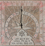
- This horizontal dial is engraved into a square block of pink granite with Roman hour numbers around the periphery and in Arabic numbers in an interior chapter ring. The gnomon was vandalized years ago and is totally missing. At the base of where the gnomon would sit is a compass rose. Southward on the dial face is the Centennial Maple Leaf and latitude/longitude and altitude. As of 2021 the dial face is rotated with noon facing due south. The square concrete pedestal has settled after 50 years and is to longer vertical.
Centennial Park was renamed to honor one of Niagara's first Black settlers, Richard Pierpoint, a Loyalist who fought in two wars. Pierpoint was captured when he was 16 years old in Senegal and brought to America to be a slave and sold to a British soldier. After the war he was given land, which includes part of the Centennial Gardens property. Pierpoint is perhaps best-known for is fighting as a soldier in the Canadian militia during the War of 1812 while in his sixties.
|
| |
General Information: | Inscription: | - Owner: City of St. Catherines
| - On Pedestal:
"Presented By
The
Gyrette Club
of
St. Catherines
1967
Engraved on the dial face:
"Centennial Maple Leaf"
LAT 43-9-40
LONG 79-14-5
SEA LEVEL 303 03
|
- Designer: Presented by Gyrette Club
|
|
|
| |
| Web Links: |
|
Last Revised: 2021-11-19 21:07