|
|
Tucson
|
Sundial: 11
|
| State/Province: Arizona |
Country: USA |
| Dial Type: Sun Alignment |
Condition: Excellent |
| |
Latitude and Longitude: |
32° 18.062' N 111° 0.456' W |
| Location: |
- Rillito River Park at unmarked entrance 1/2 mile east of La Cholla Blvd south of River Rd on the north bank of the river
|
| |
| Description: |
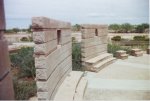
- A "Stonehenge" or sun circle dial designed by Chris Tanz, Susan Holman, Paul Edwards and with the help of Will Grundy and sponsored by the Pima County Flood Control and Transportation Dept. The structure uses a broken circle of walls to create designs made of light based on the movement of the sun. The circle, 50 feet in diameter with 8 foot walls is modeled loosely on the Casa Rinconada kiva ruins in Chaco Canyon, N.M. The walls are of integrally colored concrete block, concrete, and flagstone. Lines on a bronze plaque indicate north and south and the direction of sunrise and sunset on the equinoxes and solstices. Holes in the wall do the same. Solar noon is marked when sunlight comes through a slot in the South wall and passes a line on the floor.
|
| |
General Information: | - Owner: Pima County, Arizona
|
- Designer: Chris Tanz, Susan Holman and Paul Edwards
|
- Builder: Sponsored by Pima County Flood Control and Transportation Dept
|
|
| |
| References: |
- Tucson Citizen, July 21, 1992
|
Last Revised: 2021-07-05 15:26